Home / Mountains / Mount Kurobegorō
Mount Kurobegorō 黒部五郎岳
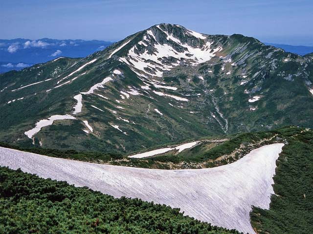

| Elevation | 2,840 m (9,318 ft) |
|---|---|
| Location | Toyama, Gifu, Japan |
| Region | Chubu |
| Famous Mountains list | No. 51 of the 100 Famous Japanese Mountains (Nihon Hyaku-meizan) |
| Coordinates | 36.3925° N, 137.54° E |
Mount Kurobegorō (黒部五郎岳, Kurobegorō-dake) is one of the 100 Famous Japanese Mountains, reaching the height of 2,839.58 m (9,316 ft). It is situated in Japan's Hida Mountains in Gifu Prefecture and Toyama Prefecture. It was specified for Chūbu-Sangaku National Park on December 4, 1934.
Outline
The origin of the mountain's name is the meaning that the stone rolls. It is called "gōro" in Japanese. This mountain is also located at the source of the Kurobe River. Then it is called "Kurobe-Gorō". On the hillside on the east side, there is a large Cirque geographical features that is a hollow where the earth was scooped out. The upper part of this mountain is situated in Tree line region, Siberian Dwarf Pine and Alpine plant grow naturally. There are quite a lot of kinds of alpine plants in the surrounding, and it is selected to "the 100 famous Japanese mountains of flower" by Sumie Tanaka.
Mountaineering
In December 1931, Buntarō Katō of Japanese mountain climber climbed it alone.
Main ascent routes
There are several climbing routes to the top of the mountain.
- Hietsu-shin-dō
- Kamioka-shin-dō
- Arimine-guchi
- The west Ginza diamond course (from Oritate – Mount Kurobegorō – to Mount Yari)
There are the Ridge Line and Cirque routes from the Kurobegorō hut to the top.
Mountain hut
Thera are several mountain huts around Mount Kurobegorō.
- Kurobegorō hut (黒部五郎小舎, Kurobegorō-goya) – in the col between Mount Kurobegorō and Mount Mitsumatarenge (with Campsite)
- Tarōdaira hut (太郎平小屋, Tarōdaira-goya) – in the col between Mount Yakushi and Mount Tarō (with Campsite)
- Mitsumata mountain cottage (三俣山荘, Mitsumata-sansō) – in the col between Mount Mitsumatagenge and Mount Washiba (with Campsite)
Alpine plant
A lot of Alpine plant are seen in the surrounding.
Rivers
The mountain is the source of the following rivers, each of which flows to the Sea of Japan.
- Nakanomata River (tributary of the Takahara River)
- Kanekido River (tributary of the Jōganji River)
- Uma River and Gorō River (tributaries of the Kurobe River)
Text adapted from the English Wikipedia article Mount Kurobegorō by its contributors, licensed CC BY-SA 4.0. Elevation and location facts cross-checked with Wikidata (CC0) and the 100 Famous Japanese Mountains list (Japanese Wikipedia, CC BY-SA 4.0).