Home / Mountains / Mount Kusatsu-Shirane
Mount Kusatsu-Shirane 草津白根山
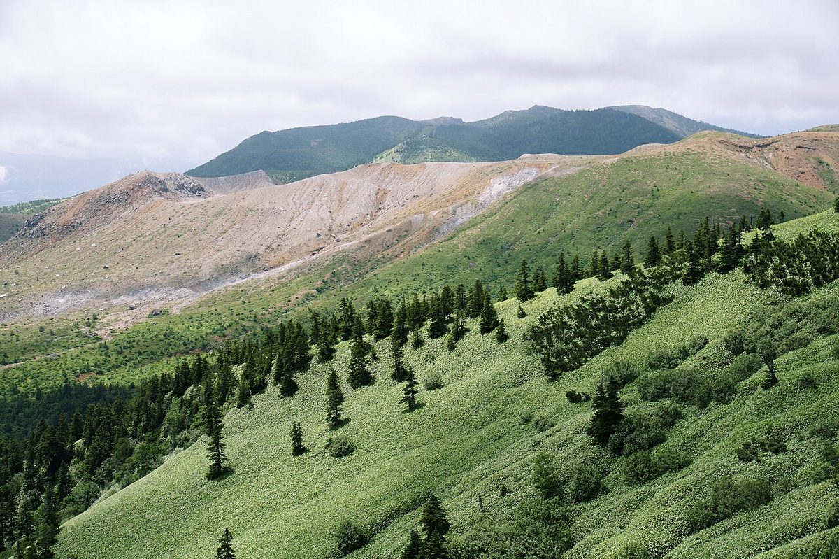

| Elevation | 2,171 m (7,123 ft) |
|---|---|
| Location | Gunma, Japan |
| Region | Kanto |
| Famous Mountains list | No. 41 of the 100 Famous Japanese Mountains (Nihon Hyaku-meizan) |
| Coordinates | 36.64528° N, 138.52833° E |
It's a compound burning hill made up of multiple burnt hills. The official name is Saoyama, but it is named by the Mount Kusatsu-Shirane, which is the name of the region in which it has to be distinguished from the others. The altitude is 2,160 meters. The Mount Kusatsu-Shirane-Tungan volcano as a volcanic volcano) contains a southern peak and a bare root mountain. In this case, the base base of the mountain will be the highest peak at an altitude of 2,171 meters.
Characteristics
It is characteristic of the mountain range near the summit, but it is said that before the eruption of 1882, the green had spread to the crater. There have been several lake craters built near the top of the mountain, and they are called Yuzu, Yuka, and Kaji. At one time there were some sulfur mines on the mountainside, and there are still traces of it. When viewed as a volcanic body, it has many craters and a single volcano clustered near the top of the mountain. The crater, formed from an eruption of some 5,000 years ago, is arranged in rows from northeast to southwest.
Yuuki
It's a lake with a diameter of about 300 meters, a depth of about 30 meters, and a temperature of about 60 degrees Fahrenheit. PH is said to be about 1.0 or so and one of the most acidic lakes in the world. This is thought to be because hydrogen and sulfur dioxide in volcano gas have melted into water and turned into hydroxide and sulfuric acid. The lake's waters produce a dark blue-green color. It is thought that such things as iron ions and sulfur in the lake's water are viewed like this because they absorb light from certain wavelengths. The bottom of the lake and the coast were sunk with sulfur sulfur, which was taken by mining companies from before the war until about 1960. At the same time, there was a sample of sulfur sulfur from steam containing sulfur sulfur from the crater. The lake shore was lined with steam and lifts for the sulfur - carrying sulfur. There were offices and workshops lined up. It is said that mine workers were often killed or injured by hot steam and volcanic gases in the eruption. There's an exhibition platform on the edge of the crater that wants hot water. And in addition to the subsequent rise of fire warning levels, we were unable to reach the area around the pot from June 3, 2014 to June 15, 2017.
Eruption warning level
In Mount Kusatsu-Shirane, an eruption warning level has been set since December 1, 2007, when weather services began operating. Gunma and Wenzu City were at a level one level and the first regulation was to limit entry within a half mile [500 m] radius from the top of the mountain bath. At first, only during the summer sighting season, they restricted the road leading to the entrance of the crater. However, since an explosion called for alarm against such small eruptions of volcanic ash within a radius of the 500-meter radius on April 10, 2009, a new eruption was announced in the crater, and the Mount Kusatsu-Shirane conference, held on April 8, 2010, saw the continuing of the First Regulation and immediate diversion. In March 2014 there was an increase in volcanic earthquakes around the tap, and since about April, there has been a slight change in the size of the mountain. After receiving further signs of active volcanic activity, on June 3, 2014, the weather service announced the eruption alarm and raised the level of fire alarm to "level level two"). Then, on June 14 of that year, the restrictions were relaxed, and at 8:00-17:00 p.m., it was possible to take the country's 2192 road through the middle of the day. However, a section of 2.5 kilometers, which runs within a mile (1 km) of the summit of the mountain, was stopped, and parking lots and stores were closed. On June 7, 2017, a drop in volcanic activity reduced the level of fire alarm to "level one active volcano" and reduced the presence of a building to within 500 meters of a mile of the boiling pot. With this, on June 15th, the control on Highway 292 was lifted, and the parking lot and sales of the store were resumed. At 10:02 a.m. on January 23rd, 2018, the blast from the Hazone River's mirror pond to the horizon, the weather station rose its alarm level by 11:5 a.m. to "level 2 a.m." and revealed that the eruptions were flying over a mile. One person was killed and 11 people injured by this eruption. Since it was an eruption, not from a bowl with a large number of security cameras pointed at it, but from an area near a mirror that had no monitoring, the weather service was caught late. At the outbreak of January 16, 2018, and March 16, 2018, weather officials decided to separate the zXQ55X's fire alarm level from the base of the base (at the edge of the hot bath). The narrowing of the control zone centered around Mount Shiba has lifted the winter closing of Joonga Shizuo Road, Japan, on April 20 of that year. However, the following night, the volcano activity near the pot became active, and on the next 22 days, it was raised to level 2. This resulted in a closed area in only two days after the winter break was lifted. On April 19, 2019, the eruption alert level of Japan's Japan Road Road has been lifted, with conditions offered by road administrator Gunma strictly. However, one of the conditions was found to be that "the distribution of flyers to stop all cars and inform them of safety response ' had not been carried out by the Tohoku tourist agency in the West, and that open cars were also passed with them and were closed again on April 24th. After that, they were released by judging the weather conditions. Even if volcanic earthquakes have been increasing since May 15th, they will be closed again from the same 18th and resume on June 1st. After that, if volcanic activity has become more active, except for winter closed periods, when volcanic earthquakes and volcanic micro-surgical activity have been observed above the standard level, then it continues to resume if activity has been quieted over a period of days or weeks or weeks.
Research
The Center for Paramagnetic Research at Tokyo's Columbia University is primarily studying Mount Kusatsu-Shirane and such things as "A Behavior of the Physic Instrument Instruments in the Mafis" and "Symbolic Instruments in the volcano" and "Symmetrics in the volcano. " The lake water in the lake and the lake bottom are made up of relatively high concentrations of elements, such as the lanthanoids, the salium, the dipplium, the itterbium, and the element that has an even number of atomic numbers, and the abundance of elements that exist is greater than that of the odd atomic numbers before and after them.
History
Here we deal with all the history of all events involving the area, including the volcano activity. The history of volcanic activity comes first and above all are regional development, disaster prevention, volcanic-related disasters, disasters, events, and so forth.
The history of volcanic activity
It'll be divided into three major activities.
Prehistoric period
I'm going to describe prehistoric volcanic activity. The major history of activity since about 10,000 years ago is as follows: Note: ka=1,000 years ago, the year 2000 is 0ka.
A historic age
I'm going to describe some important volcanic activity in the historical age. It covers the entire activity of Mount Kusatsu-Shirane in general, but if the name of the mountain has not been specified, it essentially refers to the Mount Kusatsu-Shirane. Among other things, the Mount Kusatsu-Shirane has been published by the Weather Service. (Music) (Music) I'm sorry, I'm sorry. (Engine, 1897) July 4 to August - a small water vapor blast. (Singing) October 1st - a small water vapor eruption. In July and September of 1902. I'm sorry. I'm sorry. (Laughter) (Laughter) A small water vapor eruption. (Music) October 1st, 1932. (Crowding) November and December - A small steam blast: (Music) (Music) April and September. (Journal Day) February 2 - A small water vapor eruption. December - a small water vapor fountain). March 2 - A small water vapor eruption) August 3rd, in the middle of Saoyama-Shoshan, three people died of volcanic gas. (Sunday, July 26, 1982) October 26 - A small steam fountain. (Sunday of December 21st - Small Water Explosives) (January 23rd in 2018) - Near the steam eruption One dead and eleven wounded by a fountain.
District History
Before World War II, sulfur mining was done near the top of the mountain. By the time of 1937, there were mining grounds and rice fields for the Kanto sulfur industry, and about 200 miners were in operation. There was an explosion on November 27, that same year, but most of it was down in the snow, so there was no damage. On October 13, 2026, the rule was lifted for the first time in eight years, but as tourists rushed in and stopped traffic on the surrounding roads, Shizuo City ended its tour on October 19th, as "the traffic of emergency vehicles could be damaged and the safety of the disaster could not be secured."
(To public transportation stop:
From Nagano Tokuta China Station to Long-Space-Steel volcano Mito. From Tokyo. I'm sorry. I'm sorry. I'm sorry. Each line will be out of use if the volcano's concentration is high.
(To the Yuzuzu soup)
And ten minutes' walk from Lesthouse.
Neighborly mountains
Shinoyama. Gégayama. - I'm going to take care of it. Fukuyama.
Text adapted from the Japanese Wikipedia article 草津白根山, whose full text was translated into English for this guide by its contributors, licensed CC BY-SA 4.0. Elevation and location facts cross-checked with Wikidata (CC0) and the 100 Famous Japanese Mountains list (Japanese Wikipedia, CC BY-SA 4.0).