Home / Mountains / Mount Shiomi
Mount Shiomi 塩見岳
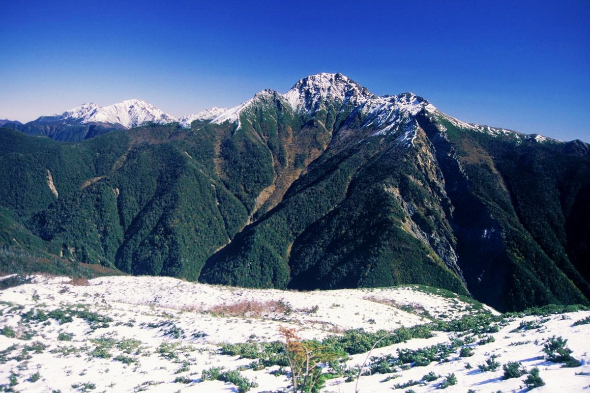

| Elevation | 3,052 m (10,013 ft) |
|---|---|
| Prominence | 505 m (1,657 ft) |
| Location | Nagano, Shizuoka, Japan |
| Region | Chubu |
| Famous Mountains list | No. 82 of the 100 Famous Japanese Mountains (Nihon Hyaku-meizan) |
| Coordinates | 35.57389° N, 138.18306° E |
Mount Shiomi It's the Bi ear peak of the eastern and western peaks. (The Red Stone Mountains) Sit in the middle, and the summit area is designated as a special protected area in South Alps National Park.
Overview
It's located at the southern edge of the long salt ridge, which follows from Narita. It's a dome-shaped mountain that looks like an iron helmet, and when viewed from a distance, it stands out like an independent mountain peak. The summit is less than 100 meters away and divides into the western and eastern peaks, with the western peaks 3,047 m and the eastern peaks 3,052 m. (East Mountain is higher at altitude, while triangle points are set at the west ridge, so on and so forth.) The summit is a fine view, and you can want most of the mountains in the South Alps, the central Alps, and Mount Fuji. The summit is the highest point in the city. the 100 Famous Japanese Mountains, New the 100 Famous Japanese Mountains, One of the hundreds of mountains in Japan.
It comes from the mountain name
There are theories that mountain names are derived from the mountain because they can be seen from the top of the mountain or because there is salt at the foot of the mountain. There is also the theory that salting smoke comes from seeing from the top of the mountain. At the foot of the mountain, there was a river called the Hausal River on the tributary, where natural salt water flowed out in the spring, and salt was installed in various areas during the drought. Then, when it became a major initiality, Mount Shiomi was used.
Environment
Mount Shiomi is located near the center of the southern Alps, where mud and sand deposited on the bottom of the ocean are formed by bumps and curves, but as part of the region, it is far north of the northern Alps. The top of the mountain is situated on the forest's edge, and its high pine belt is the home of the walnuts, the lily, the lily, the chrysanthemums, the tassels, the tassels, the tassels, the pontoons, the daisies, and other alpine plants. And on the lower side, the coniferous forest fills the mountainside. Since the end of Meiji's rule, slabe, corn, and tugga have been cut out as pulp raw material. The peak is about 700 meters below the base of the sub-capital market, and the temperature is about 14 degrees below zero. For this reason, sometimes it snows on top of the mountain until late in spring. In recent years, deer and other wild animals have come up to the top of the trinitary pass and have eaten up all the young mountain plants that feed the butterflies and have disturbed the ecosystem. In the local deer village, they catch too many deer as a protection against deer eating, and they make their meat a local brand under the name "The Great deerzivier."
History
In 1902, Akinosuke, the whole house, climbed for measurements and then a double triangle was set up. On July 21st, 1917) On the 21st day of July, 7-year-old Mount Akaishi climbs from the hot spring of Nishiyama. In 1918, Yoichi Yoichi and Kunichi Takeda ran up the north of the South Alps. On March 31st of the year 1935) On March 31st, the Indo-Change English of the Tao University of the mountains climbed the snow from the northern border. In 1935, Masatori Tataro, manager of the Lego salt hot springs, built a three-legged cabin. About the year 1960, the Saito Rock Man opened a salt shack. I was assigned to South Alps National Park on June 1st. In 1993, the Tornado Forest road was opened, and many climbers began to climb up to Mount Shiomi from the foothills at the end of this path. Prior to that, mountain roads from the Salt River hut were used by many climbers. From 1997 on, such as water pollution in the water fields due to the increase in mountain climbers, it has been banned from camping in salt sheds. From 2000 to 12 years old, salt-stained cabins have done away with underground sewers and have done so by helicopter transport.
Climbing
In 1929, Sakura Ogawa climbed up from the trigon. It wasn't until the construction of a three-driven hut in 1957 that the average climber got up. Generally speaking, they use the route from the forest road to travel back and forth through the mountain peak through the triding pass. Some climbers go back and forth on their way home from work. According to the graying of the mountains of Nagano, the root strength from the forest path is "7" - more than 2 nights in 10 stages; the technical difficulty is the fourth of 5 stages; the hard rocks, the unstable grebes, the ladders, and in some places, snow and crossovers. Climbing is a good period from mid-June to early October. In winter, Mount Shiomi Batres on the north and south of the mountain will be subject to snow climbing.
It's the cabin around here
There are several cabins open during the climb season at the peak of the climb. The salt bar is the closest cabin to the top of the mountain, and it's a full reservation. In most cabins in the South Alps, a part of the facility is open for emergency evacuation outside the business period. There used to be a three-bed on the trinities along the trinities that came down from the trinities pass, but it was shut down in 2003 for environmental protection.
Traffic access
It's 24.6 kilometers east of JR
Geography
It's on the main line of the South Alps, and on the north side, there's a low-frequency mountain. From the east side of the summit, the ridges will rise to the two cabin doors. From the top of the mountain there is a salt shack and a fresh ridge that extends through the right guard mountain to the trigon road. From the main mountain on the west side, long ridges extend north and west over Mount Haji. There's a north bank on the south side.
The river from the source stream
The following rivers, from which we come, flow into the Pacific. Iseshima, Japan, will leave on the south slope of this mountain. As the trigon's tributaries, the south rough river begins on the northern slope of our mountain. There's a beautiful lake in the 28.2 kilometers northwest.
A related library
We're going to have to do something about it. "the 100 Famous Japanese Mountains Mapbook of 2008" ISAN 978-4-8062-0599-999.
Text adapted from the Japanese Wikipedia article 塩見岳, whose full text was translated into English for this guide by its contributors, licensed CC BY-SA 4.0. Elevation and location facts cross-checked with Wikidata (CC0) and the 100 Famous Japanese Mountains list (Japanese Wikipedia, CC BY-SA 4.0).